Google plans to bring more updates to Google Maps later this year, including an immersive, almost photorealistic view of the world around you. As if filmed by a drone, users can get a bird’s-eye view of a city’s details, landmarks, traffic, and weather.
To make this happen, Google stitches together billions of satellite and Street View images and, through advances in 3D mapping and machine learning, generates a high-resolution image of a city that Google has dubbed “Immersive View.” Using the example of London, Google showed how the map view changes from a top view to a bird’s eye view deep into the city, like a virtual drone flight. The example of Westminster in London showed that Google Maps will in the future offer an area for the new view in the detail view of a view.
See traffic and weather “live”.
In the immersive view, you can jump between views, such as Big Ben, and other details can be retrieved on the map, such as the current traffic situation or weather. Through a timeline at the bottom of the screen, users can see “live” how the weather will develop over the next few hours. Appropriately enough, Google Maps animates the sky and also shows the expected showers.
Fly from the street to the restaurant
The change of buildings and restaurants is impressive. From the Street View view, the new Google Maps will be able to switch seamlessly to the interior view of a restaurant, for example (in the video at 8:50 a.m.), as if Google had also flown over this place with a drone. As Alphabet/Google CEO Sundar Pichai explained in the keynote, the view is generated solely from photos using neural rendering. According to Google, the immersive view works on almost all smartphones and similar devices.
Immersive View will first be offered to the cities of Los Angeles, London, New York, San Francisco and Tokyo later this year. However, other cities are being planned, Google said.
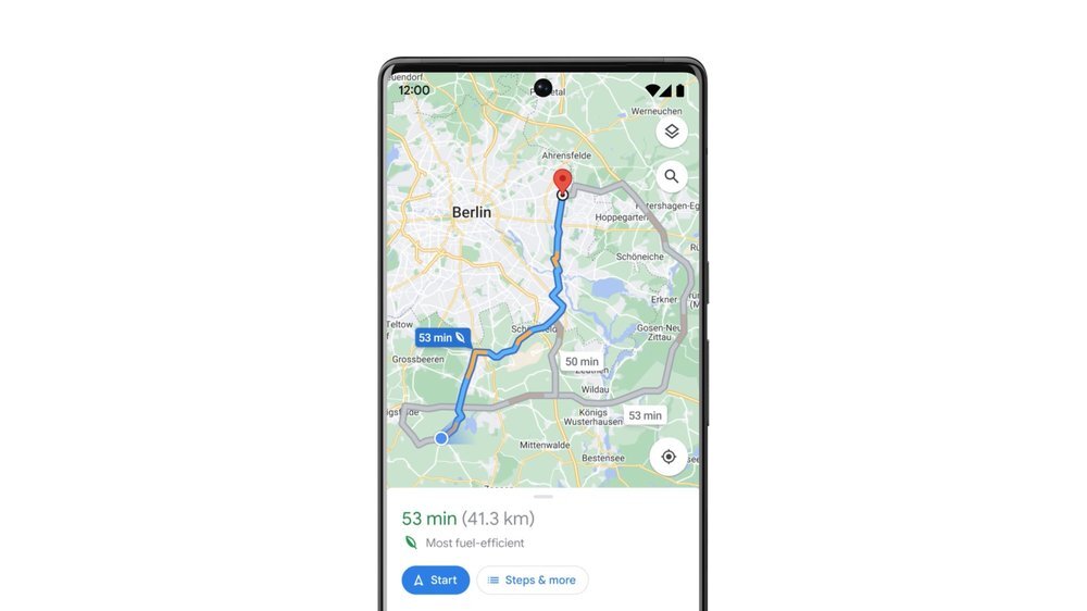
Climate-friendly route planning for Europe
In addition, Google announced that it would also bring climate-friendly route planning on Google Maps, i.e. navigation based on the most fuel-efficient route rather than the fastest, to Europe after it has already been introduced in the USA and Canada. A screenshot of the Berlin region shows that Germany also refers to this.
Developer Live View
Relevant to developers is the free provision of Live View via the ARCore Geospatial API, so that third-party applications can also use the feature in the future. Live View is used in Google Maps to display helpful arrows and directions directly on the screen over the real image using augmented reality. The feature can be useful when navigating on foot on the street or in complex buildings such as airports, shopping malls, or train stations. Live View can also be used to find the reserved seat or restrooms in a stadium, or to offer AR-enabled games as a real-world overlay.

Toni Morrison was a celebrated American author whose novels earned worldwide recognition for their depth, artistry, and cultural significance. Her influential works continue to inspire readers and writers across generations.